For decades, surveying, land administration, and property transactions in Nepal have grappled with the complexities of dual customary measurement systems, manual parcel boundary calculations, and cumbersome coordinate conversions. Developed by Binod Bhatt (BRB), Land Solution has emerged as the premier all-in-one software ecosystem designed specifically for survey engineers, Amin, real estate developers, local government palikas, and property owners across Nepal.
Whether you need rapid, error-free conversions between Ropani-Aana-Paisa-Daam and Bigha-Kattha-Dhur, full-fledged Cadastral Map Plotting, or automated Kitta-Kaat (Polygon Splitting) according to government survey guidelines, Land Solution provides unmatched mathematical precision on both Android mobile devices and Windows PC workstations.
1. Dual Land Measurement Engines: Complete Mastery Over Nepali Units
Nepal's topographical and administrative diversity relies on two distinct land measurement frameworks. Land Solution provides dual native calculating engines with instantaneous, micro-precision conversions:
🏔️ Pahad & Valley: R-A-P-D System
- 1 Ropani = 16 Aana = 5,476.00 Sq. Feet (508.74 Sq. Meters)
- 1 Aana = 4 Paisa = 342.25 Sq. Feet (31.80 Sq. Meters)
- 1 Paisa = 4 Daam = 85.56 Sq. Feet (7.95 Sq. Meters)
- 1 Daam = 21.39 Sq. Feet (1.99 Sq. Meters)
🌾 Terai & Plains: B-K-D System
- 1 Bigha = 20 Kattha = 72,900.00 Sq. Feet (6,772.63 Sq. Meters)
- 1 Kattha = 20 Dhur = 3,645.00 Sq. Feet (338.63 Sq. Meters)
- 1 Dhur = 16 Kanwa = 182.25 Sq. Feet (16.93 Sq. Meters)
- 1 Kanwa = 11.39 Sq. Feet (1.06 Sq. Meters)
Users can input raw field tape measurements in Feet, Inches, Meters, or Links, and Land Solution computes exact fractional units down to thousandths of a Daam or Kanwa with 100% mathematical consistency.
2. Cadastral Map Plotter Pro & Precision Kitta-Kaat (Polygon Splitting)
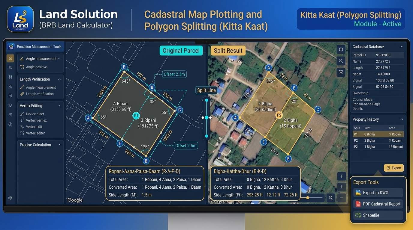
Cadastral Map Plotting and automated Polygon Splitting (कित्ताकाट) inside Land Solution: Interactive vertex adjustment, offset lines, and live area balancing.
The hallmark capability of Land Solution is its latest Cadastral Plotter Pro. Instead of relying on expensive third-party CAD suites, surveyors and Amin can perform land parcel mapping directly in the field:
- Intelligent Polygon Splitting (कित्ताकाट): Effortlessly divide any irregular polygon parcel by desired target area (e.g., cut exactly 4 Aana or 10 Dhur), fixed frontage, or parallel offset lines. The software automatically calculates the exact coordinates of the dividing line.
- Traverse & Coordinate Geometry (COGO): Input bearing and distance (Azimuth) or total station point coordinates to construct parcel boundaries with automatic closing error analysis and Bowditch balancing.
- Side Lengths & Interior Angles: Displays all vertex angles, perimeter measurements, and side dimensions simultaneously in both metric and imperial units.
3. Advanced Geodesy: Nepal MUTM Grid & GNSS Integration
Nepal's official national grid is based on the Modified Universal Transverse Mercator (MUTM) projection referencing the Everest 1830 spheroid, divided into three central meridian zones:
- MUTM 81° CM: Covers Far-Western & Mid-Western regions (Sudurpashchim & Karnali Provinces).
- MUTM 84° CM: Covers Western & Central regions (Gandaki & Lumbini Provinces).
- MUTM 87° CM: Covers Kathmandu Valley, Bagmati, Madhesh, and Koshi Provinces.
Land Solution features built-in forward and inverse geodetic transformation routines, converting WGS84 GPS Latitude/Longitude coordinates into official Nepal Survey Department Northing/Easting coordinates with sub-centimeter geoidal height correction via the EGM2008 Nepal Geoid Model.
4. Napi Karyalaya & LIS / SAEx Interoperability
For professional surveyors working with the Government of Nepal's Survey Department (नापी विभाग), seamless data transfer is essential. Land Solution is built to integrate directly with existing Land Information Systems (LIS) and Survey Automation Extension (SAEx) workflows:
- Shapefile (.shp) Import/Export: Read and write GIS shapefiles, ESRI spatial layers, and parcel attribute tables directly.
- Spatial Database (.mdb) Compatibility: Connect natively to standard LIS scratch and spatial data templates (BLANK81, BLANK84, BLANK87).
- Preeti & Nepali Font Printing: Generates official parcel trace sheets, field book schedules, and salary slips formatted in authentic Nepali Unicode and Preeti fonts for immediate legal and administrative submission.
5. Platform Availability: Android App & Windows PC Edition
Land Solution is built on modern high-performance Flutter architecture, delivering a fluid, unified user experience across devices:
| Platform | Latest Version | Key Highlights | System Requirements |
|---|---|---|---|
| Android APK | v2.8.5 (arm64 / v7a) | On-site GPS survey, offline area calculation, quick touch parcel drafting, WhatsApp export | Android 8.0 or higher |
| Windows PC Edition | v2.8.5 Desktop (ZIP) | High-resolution multi-monitor plotting, batch Shapefile import, DWG export, PDF print generator | Windows 10 / 11 (64-bit) |
Lead Developer: Binod Bhatt (BRB) • Founder & Lead Systems Engineer (@binodbhatt on GitHub)
License & Distribution: Free / Proprietary Cadastral Engineering Utility. Direct software binaries and licenses are provided directly via email to verified civil engineers, survey Amin, and municipal planners to guarantee authenticity. Zero third-party installers, adware, or unverified packages.
Download Land Solution
Help your field surveying, property valuations, and engineering workflows with Nepal's most trusted cadastral companion. Choose your platform below to get started:
Android APK (v2.8.5)
Optimized for 64-bit and 32-bit Android smartphones. Field-ready with offline GPS satellite integration and instant unit conversion.
Windows PC (v2.8.5)
Standalone desktop utility for office plotting, batch shapefile processing, AutoCAD DWG exports, and official report generation.
- ⚡ NTA MDMS Registration Nepal 2026: Step-by-Step Online Process, Documents, Fees & IMEI Verification
- ⚡ Tesla Delays Roadster, Secures $30B Credit for Cybercab & Optimus
- ⚡ Snapdragon 8 Elite vs Dimensity 9400: Qualcomm’s 4.32GHz Oryon Architecture Clashes with MediaTek’s All-Big-Core Beast
- ⚡ Apple's Secret 'Screenless' Fitness Tracker: Why Cupertino Is Building a Minimalist Whoop Rival
- ➔ Tesla Delays Roadster, Secures $30B Credit for Cybercab & Optimus
- ➔ Snapdragon 8 Elite vs Dimensity 9400: Qualcomm’s 4.32GHz Oryon Architecture Clashes with MediaTek’s All-Big-Core Beast
- ➔ Apple's Secret 'Screenless' Fitness Tracker: Why Cupertino Is Building a Minimalist Whoop Rival
- ➔ Why 'Bedazzle Everything' & Digital Maximalism Are Dominating TikTok & Tech Accessories in 2026
More Verified Nepal Digital Utility & Telecom Guides
Explore our practical Nepal technology, banking, and telecom reference guides built for local engineers, remote workers, and smartphone buyers:
- NTA MDMS Registration Nepal: Complete Online IMEI Verification Guide — register foreign-bought phones legally with customs clearance receipts.
- NTC & Ncell 5G Nepal Rollout: Bands, Speed Tests & Supported Devices — verify n78/n41 band compatibility before upgrading hardware.
- Nepal Freelancing Dollar Income, Bank Settlement & 5% Tax Guide — navigate foreign-exchange remittance rules and PAN filing cleanly.



💬 Reader Discussion & Feedback 0